NSCC research predicts storm surge flooding and erosion
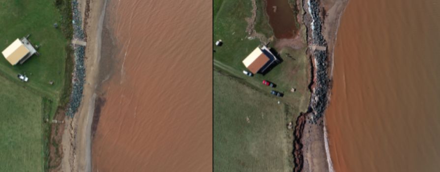
Aerial imagery of the Northumberland Shore coastline. The left image was taken before Hurricane Fiona, the right after.
Nova Scotia Community College’s (NSCC) dedicated team of coastal mapping researchers have developed an online tool to help Atlantic Canadians prepare for coastal flooding from storms. Combining years of mapping data from past projects with high-resolution elevation data collected from an aircraft using lidar technology, NSCC’s Applied Geomatics Research Group (AGRG) constructed an online flood risk mapping system.
AGRG has been conducting flood studies for coastal communities for many years now. They have been sharing their data with municipalities, provincial governments, Environment and Climate Change Canada and the Emergency Management Office of Nova Scotia to help them project what past benchmark storms would look like in the future with increased sea-level rise.
There are many factors to consider when predicting flooding, such as predicted tide, storm surge and total water levels. In the past, understanding and layering the different flood factors could be confusing since the marine and land components use different vertical references, AGRG wanted to simplify the process for users. They applied for and received funding from the Emergency Preparedness Program to build a web-based system that would link all the data in one space, known as their Emergency Coastal Flooding Decision Support System.
The online tool links predicted tide and storm surge, up to 10 days in advance, interactively with the flood map. When the user clicks on the water level chart, the flood inundation map is automatically updated. Users can increase the water level using a vertical slider bar to incorporate the potential effects of waves and long-term sea-level rise. There’s also an option to overlay the flood layer with critical infrastructure like roads, locations of fire, police and ambulance service, and continuing care facilities to determine if they are at risk of flooding.
Dr. Tim Webster explains what drove him and his team to pursue this project:
“The goal of this project was to allow easy access to lidar maps and the coastal flood layers. It provides valuable information for surge predictions from storms and hurricanes as well as for people wanting to do long-term planning that need to consider sea-level rise in the next 50 to 100 years. For example, many planners use the tool when looking at infrastructure that could be vulnerable or planning new infrastructure that is expected to have a lifespan of over 50 years.
One of the biggest impacts for Atlantic Canada from climate change will be increased sea-level rise. This tool allows people to raise the sea-level and see what will get flooded.”
AGRG’s flood risk support system was in high demand leading up to and following Hurricane Fiona which made landfall on Sept 24, 2022. Dr. Webster noted, “The site was accessed by lots of people prior to Fiona making landfall and it did not crash which was a test of its design and implementation using ESRI GIS tools.”
More impressive still, was that the predictive models were quite accurate. While their system showed the same variation in the total water level along the Northumberland Shore and were consistent with the Environment and Climate Change Canada storm surge predictions, Dr. Webster and team were still impressed by the power of the storm which resulted in a significant amount of damage to coastal features.
“The erosion and flooding were the worst we have seen in the 20 years that we have been mapping and documenting such events,” said Dr. Webster.
Thank you to Environment and Climate Change Canada for supplying the storm surge predictions, Department of Fisheries and Oceans for supplying the predicted tide and all three Maritime Provinces who have supported the project and provided data on the location of their emergency services. A special shout out to the Province of Nova Scotia’s GeoNOVA, who is currently testing the system on one of their web servers. They plan to eventually host the site as a secondary location to support their mandate of access to geographic information that helps people make better decisions. This project was funded by Defense Research and Development Canada.